|
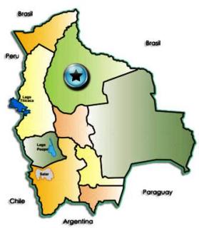
Welcome to Beautiful Beni Bolivia! The Department of Beni, Bolivia covers 213,564 square kilometers in area and currently has about 420,000 inhabitants. About 100,000 live in the department’s capital city of Trinidad. Beni borders the state of Pando and Brazil to the North; Brazil and the state of Santa Cruz to the East; Santa Cruz, Cochabamba, and La Paz to the South; La Paz and Pando to the West. It's Bolivia's second largest state.
It was created on 18 November 1842 during the government of José Ballivian, shortly after Bolivian won its independence in 1825. Much of Beni is at about 155 meters above sea level. Although most of the department is flat, along the border with La Paz there are two sierra chains called Eva Eva and Pelado. Beni is criss-crossed by numerous Rivers, all of which are Amazon tributaries. The largest of these are the Iténez (also known as Guaporé), Mamoré, Madre de Dios, Madera, Yata, Ivón, Machupo, Itonama, Baures, San Martín, San Miguel, San Simón, Negro, Sécure, Yacuma, Maniquí, Ibare and Apere, all of which are navegable. Beni also has numerous lakes and lagoons. The most important of these (and many of them are included in tour routes) are: Laguna Suárez, Rogagua, Rogaguado, San Luis, San Pablo, Huachi, Huatunas, Yusala, Huachuna, Agua Clara, Ginebra, La Dichosa, Bolivia, Navidad, Las Abras, Larga, Maracaibo. There are many many more! Other important cities are Guayaramerín, Riberalta, and for tourism,
Rurrenabaque.
 Because of this geography, Beni was a very important center of pre-Colombian civilization known as the hydraulic culture of Las Lomas (the hills), a culture that constructed over 20,000 man-made artificial hills, all interconnected by thousands of square kilometers of aqueducts, channels, embankments, artificial lakes and lagoons, and terraces. Between about 4000 BC (and probably earlier as this date is taken from ceramics that have been carbon dated) and the 13th Century AD this region was settled by important and organized groups of human societies. Their civil structures were based, both environmentally and economically, on the use of specific environmental characteristics (such as the use of aquatic plants as fertilizer, and enormous fishing systems they constructed). You can still see miles and miles of these channels and man-made hills if you fly low over Beni. The BBC recently ran an article about how amazingly, many farmers in Beni are now going BACK to this system of agriculture and irrigation. That's because Beni floods seasonally and in recent years the floods have been especially damaging. So people are going back to ancient wisdom to find solutions to modern problems. When the Spanish arrived the region had already been in decline for about three hundred years. However, this is where many products that are now used worldwide have their origin, among them tobacco, peanuts, cotton, yucca (manioc), vanilla and sweet potatoes. The Spanish initially were intensely interested in this area. During the first century of colonization, they believed the mythical city of El Dorado (also known as Paititi) could be found in this region. However, they never found this legendary city of gold and they soon lost interest in the area, which would remain marginalized for several centuries after. Between the 19th and 20th Centuries northern Beni became Bolivia’s rubber capital. The abundance of rubber trees attracted many people to the region, many of them adventurers and others workers (many of whom were indigenous) to work in the huge rubber plantations that arose. For decades it was one of the most active, dynamic regions of Bolivia. Cachuela Esperanza was an important center for rubber exports as it is located along the shores of the Beni River. It had one of the best equipped hospitals in Bolivia at the end of the 19th Century. But these enormous rubber plantations all but disappeared by the end of the Second World War and today many of them are cattle ranches. There are only some small rubber producers who still use the river to transport their production. Beni is one of Bolivia’s nine departments (states) and each department is headed by a Prefect whose functions are similar to that of a governor. Prefects are elected for a five-year term. Prior to 2005 prefects were assigned by the President of Bolivia. Each department has provinces. Beni has 8 provinces: Cercado (capital is San Javier); Vaca Diez (capital is Riberalta); José Ballivian (capital is Reyes); Yacuma (capital is Santa Ana de Yacuma); Moxos (capital is San Ignacio de Moxos); Marbán (capital is Loreto); Mamoré (capital is San Joaquín); and Iténez (capital is Magdalena). Each of the eight provinces is divided into counties. There are 48 counties total in the Department of Beni. The government of Beni also has a Departmental Council, similar to a state legislature, with 12 members called Council members. Each province is represented by 1 council member (elected) and the remaining 4 are assigned according to the number of inhabitants of each area. Beni is hot and humid during most of the year with an annual rainfall average between 1000 millimeters and 4000 millimeters. It is one of the wettest regions in Bolivia, with more wetlands that the better-known
Bolivian Pantanal.
Beni is covered in savannahs and pastures and has numerous lakes and lagoons as well as many important rivers, all large tributaries of the Amazon River. Read about the
Pink River Dolphin Tour.
In the region’s many rivers over 400 species of fish have been found (Trinidad has dedicated an entire museum to Beni’s fish fauna and it is the third largest of its type in South America ) called the Museo Ictícola. The most commonly fished and consumed species are pacú, tambaquí, surubí, palometa (a type of piranha), sábalo, bagre (catfish), and blanquillo. Alligators are also hunted for their leather and meat, which is considered a delicacy and is a common part of meals in Beni. Beni now also exports huge amounts of lumber, although over the past 20 years the government of Bolivia has worked with numerous international entities and NGOs to certify it’s lumber concessions and all lumber exported must be accompanied by certificates of origin. Many different ethnic groups have inhabited what is now the Department of Beni over many thousands of years. Today, most “Benianos” are of mixed race. The main ethnic groups that currently inhabit the area are the Sirionó, Moxeño, Yuracaré, Moré, Pausema, Baure, Canichana, Chacobo, Esseja, Tacana, Chimán, Movima, Cayubaba, and Itonoma (these are just some of the 36 ethnic groups of Bolivia). Many of these ethnic groups were “converted” to Catholicism by the Jesuit missionaries who arrived in what is now Bolivia five hundred years ago. In today’s Department of Beni the Jesuits, and in some cases Franciscans, established mission settlements which remain today. The Jesuit priests Castillo, Pedro Marbán and Cipriano Barace were sent from Lima to Santa Cruz in 1675. From there they moved northward to the area known as Moxos (Beni was given its name and departmental status in the 1800’s). They founded the first mission in Loreto in 1682 and others followed. The largest of these is Trinidad, now the capital of Beni. Others (included in what is known as the Missions Tour) are San Javier, San Pedro, Santa Ana, Exaltación, San Ignacio de Moxos, San Borja, Reyes, Magdalena, Concepción, San Simón, San Joaquín and San Nicolás. The Jesuits were expelled from the region by the King of Spain in 1767 (he had many of them hunted down and killed) but these towns have preserved many of the customs taught them by the Spaniards (such as fashioning hand-carved violins and other musical instruments and playing baroque music.) In many other towns and villages life has changed little. Although inhabitants now wear Western-style clothing they continue to farm small family-sized crops, mostly at a subsistence level. Many still use the traditional modes of transport such as hollowed-out wooden canoes and horses-and-carts with large wooden wheels on dry land. The Jesuits introduced cattle ranching and horses to the region. Some tours include visits to small towns like Ibiato and Casarabe, the mission towns, and others near Trinidad, Rurrenabaque, Riberalta and Guayarmerín. Visitors can meet the warm and friendly inhabitants of this region and learn about their customs and traditions. Benianos are working hard to conserve their natural surroundings with natural parks and reserves. Chuchini is one such eco-reserve and there are others. Today the population of Beni comprises less than 10% of Bolivia’s total population. Even though Bolivia’s 3 Eastern departments of Beni, Santa Cruz and Tarija together cover over 60% of national territory, (and because the national government has done little to educate the population or foreigners about the Eastern half of the country), most people believe Bolivia to be a primarily Andean country and few think of tropics or the Amazon when Bolivia comes to mind. Also interesting to note is that of the roughly 30 ethnic groups that inhabit Bolivia, about 85% of them live in Eastern Bolivia, roughly 15 of them in Beni alone. Read more about the history of Beni here. Beni's population and popularity are on the rise again. The Prefecture is working hard to improve and increase tourism to the region. The city of Trinidad has a new slogan: Trinidad Verde (Green Trinidad). Beni truly is Bolivia's green paradise. If you entered this page from our history pagesPando La Paz Oruro Potosí Chuquisaca |
