Tourism in Bolivia: Interactive Map Shows Road Blocks and Closures
by BoliviaBella.com
(Santa Cruz, Bolivia)

Unexpected road closures and road blocks can happen at any moment in Bolivia, a country with a highly varied topography and even more highly politicized society. Many of Bolivia's roads are not paved, some are dangerous simply because they are carved into the sides of mountains and are prone to landslides or erosion, and still others (especially main arteries between major cities) are frequently blocked by protesters as a way to pressure the government to concede certain requests.
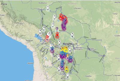
Few things can spoil an otherwise beautiful trip through Bolivia more suddenly than collapsed or blocked roads, as the country has just a few usable main highways and arteries. The ABC (Administradora Boliviana de Carreteras or Bolivian Highway Administration) keeps an updated interactive map on its website that can be consulted at any time, day or night. This very useful map is color coded to show the following:
In yellow: roads that are passable but may have detours.
In blue: roads that are blocked by protesters and impassable.
In orange: roads that are completely closed to any traffic.
In purple: roads that are passable only to lightweight vehicles.
In white: sections of roads that are being carefully monitored.
Super useful for tourists and travelers. The map is updated several times per day. VIEW THE MAP here.
Join in and write your own page! It's easy to do. How? Simply click here to return to Travel Tips.